
The Westfjords by car: roads, distances and when to go
Last updated: 10 November 2026
Prepared by Ring Road Cars at Keflavík Airport and checked against the official sources listed at the end of this page.
Short answer
From Reykjavík, the paved road to Ísafjörður runs via Hólmavík on road 61: 455 km, at least 5 h at 90 km/h (498 km from Keflavík Airport). Route 60 past Dynjandi is shorter, 414 km, but about 18 km of it is still gravel. Plan at least five days for the loop with Látrabjarg, seven to add Strandir. In winter the main roads are cleared daily, Dynjandisheiði only Monday to Friday, and the road to Látrabjarg not beyond Örlygshöfn. We strongly advise AWD; ferries are at your own risk under our rental terms. Check umferdin.is and vedur.is before every leg.
Getting there: two roads from Reykjavík
Both start on Route 1 through the Hvalfjörður tunnel (no toll) and Route 60 over Brattabrekka, past Búðardalur (153 km from Reykjavík). Beyond Svínadalur they split:
- Road 61 via Hólmavík, paved all the way: over Þröskuldar and Steingrímsfjarðarheiði and round the fjords of Ísafjarðardjúp (Visit Iceland also gives 455 km).
- Route 60 via Dynjandi, shorter but not yet all paved: along Breiðafjörður to Flókalundur, over Dynjandisheiði, through the Dýrafjörður tunnel and over Gemlufallsheiði.
| Destination | From Keflavík Airport | From Reykjavík | Gravel (from Reykjavík) |
|---|---|---|---|
| Hólmavík (roads 60 and 61) | 276 km (3 h) | 233 km (2 h 35 min) | None |
| Ísafjörður via Hólmavík (road 61) | 498 km (5 h 30 min) | 455 km (5 h) | None |
| Ísafjörður via Dynjandi (Route 60) | 457 km (5 h 5 min) | 414 km (4 h 35 min) | 18 km |
| Dynjandi (Route 60) | 399 km (4 h 25 min) | 356 km (3 h 55 min) | 10 km |
| Patreksfjörður (roads 60 and 62) | 431 km (4 h 45 min) | 387 km (4 h 15 min) | 9 km |
These are the official distances of Vegagerðin, the Icelandic Road and Coastal Administration (distance tables, in Icelandic). Airport figures start at the terminal; our office at Bogatröð 1 in Reykjanesbær is about 10 minutes away by our airport shuttle.
A long first day, and no mountain shortcuts
Ísafjörður is at least 5 h 30 min from the airport, and Safetravel warns of drowsiness after an overnight flight: consider a night in Hólmavík (276 km). Ignore navigation-app shortcuts: our rental terms never allow F66 (Kollafjarðarheiði) in any car (clause 16), and road 608 over Þorskafjarðarheiði is mostly gravel, with no winter service.
The Westfjords loop, leg by leg
The loop follows Visit Westfjords' own seven-day itinerary: north to Hólmavík and Ísafjörður, south past Dynjandi to Patreksfjörður and Látrabjarg, back on Route 60:
| Leg | Main roads | Distance | Gravel | Minimum at the speed limits |
|---|---|---|---|---|
| Reykjavík → Hólmavík | 1, 60, 61 (Þröskuldar) | 233 km | None | 2 h 35 min |
| Hólmavík → Ísafjörður | 61 (Steingrímsfjarðarheiði) | 224 km | None | 2 h 25 min |
| Ísafjörður → Bolungarvík and back | 61 (Bolungarvíkurgöng) | 26 km | None | 15 min |
| Ísafjörður → Þingeyri | 60 (Vestfjarðagöng, Gemlufallsheiði), 622 | 49 km | None | 30 min |
| Þingeyri → Dynjandi | 622, 60 (Dýrafjarðargöng), 621 | 28 km | 9 km | 15 min |
| Dynjandi → Patreksfjörður | 60 (Dynjandisheiði), 62 (Kleifaheiði) | 90 km | None | 1 h |
| Patreksfjörður → Látrabjarg and back | 62, 612 | 118 km | 68 km | 1 h 20 min |
| Patreksfjörður → Reykjavík | 62, 60, 1 | 387 km | 9 km | 4 h 15 min |
| Total | The loop from Reykjavík | 1,155 km | 86 km | 12 h 35 min |
Times assume 90 km/h on paved road and 80 km/h on gravel, without stops. Between Patreksfjörður and Dynjandi, take the paved roads 62 and 60, not road 63 via Bíldudalur (24 km of gravel, no winter service on its last stretch).
Tunnels, and no tolls
The Dýrafjörður tunnel opened in October 2020, and the Vestfjarðagöng tunnel's arm toward Önundarfjörður is single-lane for 4.1 km: watch the signs for who gives way. No tunnel here charges a toll, nor does the Hvalfjörður tunnel; in Iceland only the Vaðlaheiði tunnel and the Hornafjarðarfljót bridge do (Tolls & parking).
The stops on the way
- Hólmavík and Strandir: a village known for its folklore, where whales are sometimes seen from land. Road 643 north is largely gravel: Drangsnes 44 km (19 km of gravel), Djúpavík 70 km (45 km), Norðurfjörður 104 km (79 km).
- Ísafjörður and Bolungarvík: the largest town in the Westfjords and, 13 km on through a tunnel, Bolungarvík at the mouth of Ísafjarðardjúp.
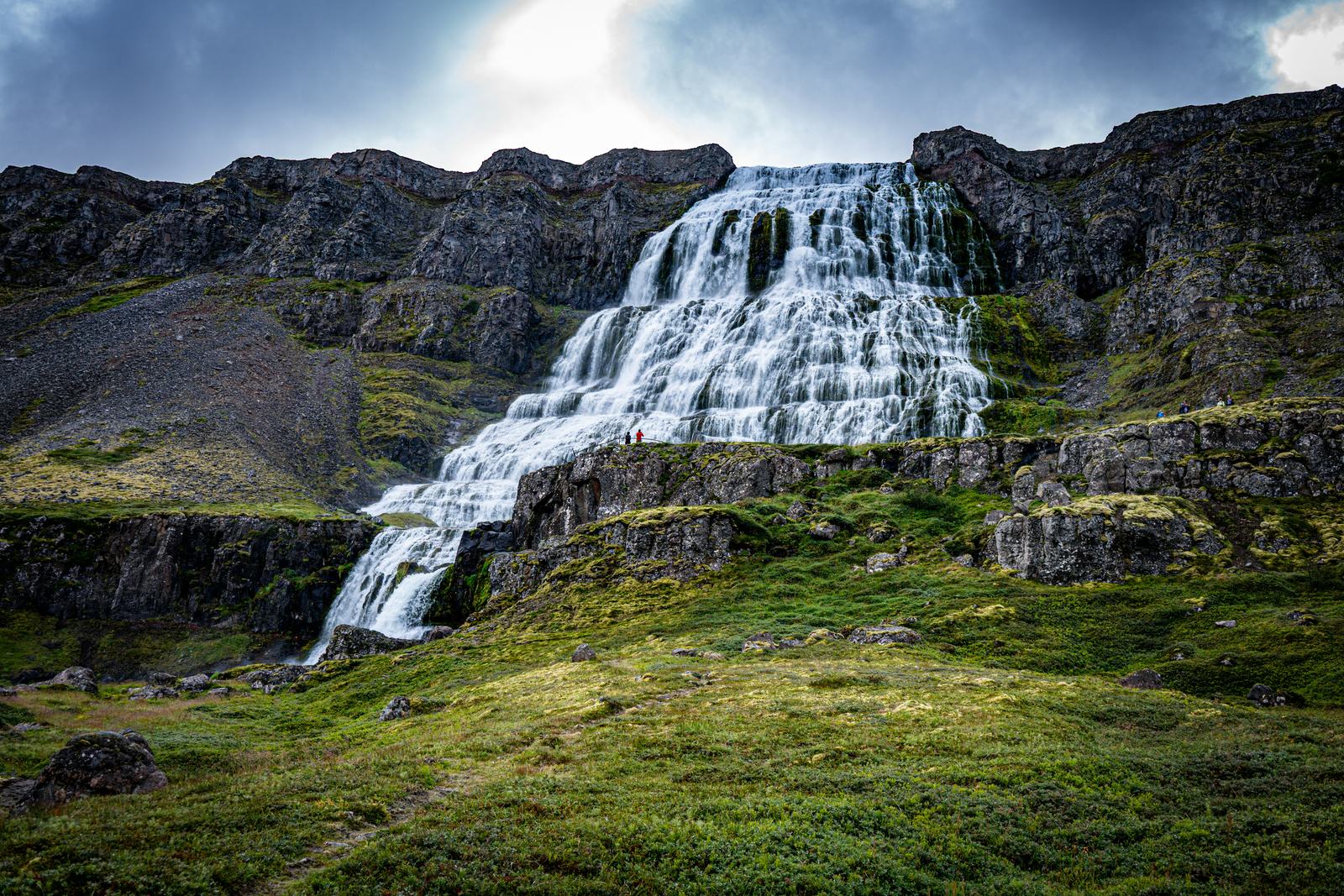
- Dynjandi: six falls stepping about 100 m down beside Route 60, the wide Fjallfoss at the top, with a path up past the lower falls.
- Látrabjarg: Iceland's westernmost point and one of Europe's largest bird cliffs, about 14 km long and up to 441 m high, with puffins best seen from late spring through July. Road 612 ends at Bjargtangar lighthouse, 59 km from Patreksfjörður, 34 km of it narrow gravel.
- Rauðasandur: about 10 km of reddish sand, down road 614 off road 612, a steep and narrow drive.
At the cliff edge
At Látrabjarg, stay behind the barriers and well back from the edge: it is fragile and can collapse without warning (Visit Westfjords). Park only in the parking area; drones need a permit.
How many days: three, five or seven
The Westfjords Way touring route is 950 km long (Visit Iceland), and Visit Westfjords' own itinerary takes seven days. Three days: in via Hólmavík, a day around Ísafjörður and Bolungarvík, out past Dynjandi on Route 60. Five: the loop above. Seven: the loop plus Strandir as far as Djúpavík and a free day in Ísafjörður.
| Plan | Nights | Driving per day | Distance | Minimum at the wheel |
|---|---|---|---|---|
| 3 days | Ísafjörður (2) | 455 · 26 · 414 km | 895 km, 18 km of gravel | 9 h 50 min |
| 5 days | Hólmavík, Ísafjörður, Patreksfjörður (2) | 233 · 250 · 167 · 118 · 387 km | 1,155 km, 86 km of gravel | 12 h 35 min |
| 7 days | Hólmavík (2), Ísafjörður (2), Patreksfjörður (2) | 233 · 140 · 224 · 26 · 167 · 118 · 387 km | 1,295 km, 176 km of gravel | 14 h 15 min |
From Keflavík Airport, add 43–44 km at each end, and plan to be near the airport the evening before you fly home.
Gravel roads, and how to drive them
Most roads are paved, but some gravel remains (Visit Westfjords). On the main roads, Vegagerðin's tables still show about 9 km on Route 60 in Gufudalssveit, east of Flókalundur, where new road and bridges are being built until 2028, and 7 km from Dynjandi to Mjólkárvirkjun, where the last phase of the new road over Dynjandisheiði was due by the end of September 2026 and is still under way. From Flókalundur, Route 60 shows paved over the heath to the falls.
- Slow down before the asphalt ends: tires can lose grip on gravel (Safetravel).
- 80 km/h is the gravel limit, often too fast: keep right on narrow stretches and slow down to meet cars, as flying stones break windshields (Vegagerðin).
- Single-lane bridges: the car closer to the bridge goes first. Sheep graze by the road; stop only off it.
- Fuel: stations are in the villages, mostly self-service pumps (N1's list): fill up before Látrabjarg and Strandir, with a card and PIN (Fuel & paying at the pump).
What gravel can cost you
No cover option, at any tier, pays for damage to the undercarriage, or to the drivetrain, engine or chassis from rough roads, grader ridges or stones (rental terms 36(g)). Tires and the windshield are covered only with TWP (Tire and Windshield Protection): the PLUS cover adds it for +€20 a day, and MAX includes it (Rental car cover). Rivers and fords are entirely at your own risk, with no cover (clause 17).
The Westfjords in winter
Vegagerðin clears these roads on very different schedules (winter service rules; umferdin.is map, 10 November 2026):
- Every day (Rule A): Route 60 to Flókalundur, road 61 to Ísafjörður and Bolungarvík, road 62 to Patreksfjörður, and Route 60 from the Þingeyri road to Ísafjörður.
- Monday to Friday (Rule C): Route 60 over Dynjandisheiði, from Flókalundur through the Dýrafjörður tunnel, and the road to Dynjandi.
- Twice a week (Rule F): road 612 to Örlygshöfn, and parts of road 643.
- Spring and autumn (Rule G): road 643 past Djúpavík; in winter once a week until 5 January, then only on request.
- No winter service: road 612 beyond Örlygshöfn, road 63 up to Dynjandisheiði, Hrafnseyrarheiði (626) and F66; road 614 has no fixed days.
So from November to March, plan on the roads cleared every day, cross Dynjandisheiði on a weekday, and leave Látrabjarg and northern Strandir for summer.
Passes and closures
Storms can close the passes for hours or days. Check the warnings on vedur.is: under an orange warning, drive only if you must; under a red one, don't travel. Never drive past a closure sign or onto a road marked Lokað: it carries the €1,000 prohibited-road fee (rental terms 16 and 40(g)), and no waiver covers the damage.
- Daylight: on 10 November the sun rose in Ísafjörður at 10:01 and set at 16:30; near the December solstice Reykjavík gets about four hours of daylight, the Westfjords less (Met Office times, in Icelandic).
- Tires and drive: winter tires on every car from 1 November to 14 April at no extra charge (rental terms 1); from November to March we strongly recommend AWD or a 4×4, though it does not stop a skid on ice (Safetravel).
The Baldur ferry across Breiðafjörður
The car ferry Baldur links Stykkishólmur on Snæfellsnes with Brjánslækur in the southern Westfjords, stopping at Flatey for foot passengers; Vegagerðin lists it as a daily service. Stykkishólmur is 172 km from Reykjavík (Snæfellsnes by car); from Brjánslækur, Patreksfjörður is 55 km and Dynjandi 35 km, while by road Brjánslækur is 332 km from Reykjavík. Check the operator's sailing schedule and book: on 10 November 2026 Baldur was in dry dock until late November.
On a ferry, the car is at your own risk
Our rental terms allow domestic ferries at your own risk: no cover option, MAX included, covers damage to the car during ferry or sea transport, including sea spray (clauses 25 and 36(j)).
Which car, and returning it
- Our call: for the Westfjords, our booking page marks 4×4 Adventure and Highland 4×4 “Ideal” and Comfort (AWD) “Good”; our 2WD cars, Everyday and Family & Space, are marked “With care”: we strongly advise AWD.
- Why: the roads to Látrabjarg, Rauðasandur and along Strandir are narrow gravel, steep in places, and passes can be snowy or icy from autumn to spring. None is an F-road, so any of our cars may drive them when they are open.
Ending your trip elsewhere? We rent from our office near Keflavík Airport, where the car goes back. Collection or return in Ísafjörður or another town is on request only, agreed in advance and priced individually, with any one-way fee confirmed in writing (rental terms 11 and 40(o); see Locations).
Car trouble: call us day or night on +354 779 9499; in an emergency, call 112 (Accident & breakdown).
Questions about driving in the Westfjords
How do I drive to the Westfjords from Reykjavík, and how long does it take?
Take Route 1 north through the Hvalfjörður tunnel, then Route 60 past Búðardalur. From there, road 61 runs via Hólmavík to Ísafjörður: 455 km, paved all the way, at least 5 h of driving. Route 60 past Dynjandi is 414 km, with about 18 km of gravel. Hólmavík is 233 km from Reykjavík, Patreksfjörður 387 km.
Is the road to Dynjandi paved, and is it open in winter?
From Flókalundur, Vegagerðin's tables show Route 60 paved over Dynjandisheiði to the falls; the short road in to the parking area and the 7 km north of the falls are still gravel, where the new road is being finished. In winter the road over Dynjandisheiði is cleared Monday to Friday, and storms can close it: check umferdin.is first.
How many days do I need for the Westfjords?
At least five for the loop via Hólmavík, Ísafjörður, Dynjandi, Patreksfjörður and Látrabjarg: 1,155 km from Reykjavík and back, at least 12 h 35 min at the wheel. Seven days add Strandir and a slower pace, like Visit Westfjords' own itinerary. Three days cover Ísafjörður and Dynjandi (895 km), with two long driving days.
Do I need a 4×4 for the Westfjords?
It is the best choice, not a requirement: for the Westfjords our booking page marks 4×4 Adventure and Highland 4×4 “Ideal” and Comfort (AWD) “Good”, and for our 2WD cars we strongly advise AWD. The main roads are paved apart from stretches under construction, but the roads to Látrabjarg, Rauðasandur and Strandir are narrow gravel, and passes can be icy from autumn to spring.
Can I take a rental car on the ferry across Breiðafjörður?
Yes, on the Baldur car ferry between Stykkishólmur and Brjánslækur, but under our rental terms domestic ferries are at your own risk, and no cover option covers damage during ferry or sea transport, including sea spray (clauses 25 and 36(j)). Check the operator's schedule first: on 10 November 2026 Baldur was in dry dock until late November.
Is there a toll on the way to the Westfjords?
No. The Hvalfjörður tunnel is free, and so are the Dýrafjörður, Vestfjarðagöng and Bolungarvík tunnels. In Iceland only the Vaðlaheiði tunnel near Akureyri and the Hornafjarðarfljót bridge near Höfn charge tolls.
Can I drive to Látrabjarg in winter?
Not reliably: road 612 is cleared twice a week only as far as Örlygshöfn, with no winter service from there to the cliffs. In summer it is 59 km from Patreksfjörður, 34 km of it gravel, and puffins are best seen from late spring through July. Stay behind the barriers: the cliff edges can collapse.
Official sources
The facts on this page come from these sources (checked 10 November 2026):
- Distances between places (Vegalengdir) — Vegagerðin, in Icelandic
- Winter service: snow-clearing rules — umferdin.is (Icelandic Road and Coastal Administration)
- Route 60 over Dynjandisheiði: the road works — Vegagerðin, in Icelandic
- Driving safely in Iceland — Vegagerðin
- How to drive in Iceland — Safetravel
- The Westfjords — Visit Iceland
- Látrabjarg bird cliff — Visit Westfjords
- Baldur ferry: sailing schedule — ferja.is (the operator)
- Rental terms — Ring Road Cars