
East Iceland by car: the Eastfjords, Stuðlagil and Seyðisfjörður
Last updated: 10 November 2026
Prepared by Ring Road Cars at Keflavík Airport and checked against the official sources listed at the end of this page.
Short answer
From Keflavík Airport, Egilsstaðir, East Iceland's main town, is 677 km via Akureyri and Mývatn, or 730 km along the south coast on Route 1. From Höfn, paved Route 1 follows the fjords to Egilsstaðir: 252 km, at least 2 h 45 min at 90 km/h. The gravel shortcut over Öxi (road 939) saves 67 km between Djúpivogur and Egilsstaðir, but our rental terms allow it only in a four-wheel-drive car your booking confirms as F-road approved. Stuðlagil is 19 km off Route 1; Seyðisfjörður is 27 km from Egilsstaðir over a pass cleared every day. Plan two days, and check umferdin.is and vedur.is before every leg.
Getting there from the south or the north
- From the south: Route 1 along the south coast via Vík and Jökulsárlón to Höfn, then through the fjords. Just before Höfn it crosses the tolled bridge over Hornafjarðarfljót: pay at spolur.is within 24 hours.
- From the north: Route 1 via Akureyri and the Vaðlaheiði tunnel (toll), past Mývatn and over the north-east highlands (Möðrudalsöræfi).
| Destination and route | From Keflavík Airport | From Reykjavík |
|---|---|---|
| Höfn (Route 1 along the south coast) | 484 km (5 h 20 min) | 443 km (4 h 55 min) |
| Egilsstaðir from the south (Route 1 through the Eastfjords) | 730 km (8 h 5 min) | 690 km (7 h 40 min) |
| Egilsstaðir from the north (via Akureyri and Mývatn) | 677 km (7 h 30 min) | 634 km (7 h) |
These are Vegagerðin's official distances (distance tables, in Icelandic), from the airport terminal; our office at Bogatröð 1 in Reykjanesbær is about 10 minutes away by our airport shuttle. Visit Iceland puts Reykjavík to Egilsstaðir at about 7.5 to 8.5 hours.
A gravel shortcut in Jökuldalur
The shortest northern route leaves Route 1 in Jökuldalur for road 924, and navigation apps may do the same: 22 km of gravel, cleared in winter only on request. Route 1 is paved all the way; stay on it in winter. An unpaid toll that reaches us is passed on with our €10 processing fee (rental terms 22 and 40(i); see Tolls & parking).
The Eastfjords on Route 1, leg by leg
Route 1, paved all the way round since 2019, follows the coast from Höfn through the fjords and the Fáskrúðsfjörður tunnel, then crosses Fagridalur to Egilsstaðir:
| Leg | Main roads | Distance | Minimum at 90 km/h |
|---|---|---|---|
| Höfn → Djúpivogur | 1 | 103 km | 1 h 5 min |
| Djúpivogur → Breiðdalsvík | 1 | 61 km | 40 min |
| Breiðdalsvík → Fáskrúðsfjörður (via Stöðvarfjörður) | 1 | 47 km | 30 min |
| Fáskrúðsfjörður → Reyðarfjörður | 1 (Fáskrúðsfjörður tunnel) | 21 km | 10 min |
| Reyðarfjörður → Egilsstaðir | 1 (Fagridalur) | 33 km | 20 min |
| Total | Höfn to Egilsstaðir | 265 km | 2 h 45 min |
Straight through, without the short roads into each village, Höfn to Egilsstaðir is 252 km; from there Route 1 runs 163 km on to Mývatn (North Iceland by car).
- Djúpivogur: a historic trading post just off Route 1.
- Egilsstaðir: the East's commercial center, on the lake Lagarfljót, with an airport. Fill up before the 163 km to Mývatn; N1, for one, lists stations in Höfn, Djúpivogur, Breiðdalsvík, Stöðvarfjörður, Fáskrúðsfjörður and Egilsstaðir.
- Reindeer: the East is the only part of Iceland with wild reindeer, so watch the road edges.
Side trips: Seyðisfjörður, Hengifoss, Borgarfjörður eystri and Stuðlagil
| Side trip | Roads | Distance | Surface |
|---|---|---|---|
| Seyðisfjörður | 93 (over Fjarðarheiði) | 27 km from Egilsstaðir | Paved |
| Hengifoss (trailhead) | 95, 931, 933 | 34 km from Egilsstaðir | Paved |
| Borgarfjörður eystri | 94 | 71 km from Egilsstaðir | Paved |
| Stuðlagil (Grund parking) | 923, 9212 | 19 km from Route 1 in Jökuldalur | 4 km of gravel |
- Seyðisfjörður: colorful 19th-century timber buildings, the waterfall Gufufoss on the way down from the pass, and the international ferry to the Faroe Islands and Denmark.
- Hengifoss: at 128 m one of Iceland's tallest waterfalls, 40 to 60 minutes up a moderately steep gravel trail of about 2 km, past the basalt columns of Litlanesfoss (Visit East Iceland).
- Borgarfjörður eystri: a village of about 100 people; puffins nest on Hafnarhólmi by the harbor from mid-April to early August.
Öxi (road 939) or Route 1 through the fjords?
Road 939 over Öxi leaves Route 1 in Berufjörður, 20 km from Djúpivogur, for road 95 in Skriðdalur; navigation apps often choose it:
| Route | Distance (minimum at 90 km/h) | Surface | Winter service |
|---|---|---|---|
| Route 1 through the fjords | 152 km (1 h 40 min) | Paved | Seven days a week |
| Öxi (roads 939 and 95) | 85 km (55 min) | 25 km of gravel | Some days in autumn and spring; from January only on request |
| Breiðdalsheiði (road 95) | 142 km (1 h 30 min) | 27 km of gravel | Some days in autumn and spring; from January only on request |
So Öxi saves 67 km, on gravel, where the limit is 80 km/h. All our cars may drive Breiðdalsheiði when it is open.
Öxi in one of our cars
Our rental terms (clause 16) allow Öxi only in a four-wheel-drive vehicle (4x4, 4WD or AWD) your booking confirms as F-road approved, and only when officially open: on our website, Comfort, 4×4 Adventure or Highland 4×4, never Everyday or Family & Space. Driving a closed or prohibited road carries the €1,000 prohibited-road fee (40(g)), and no waiver covers the damage.
Stuðlagil canyon: the road and the two sides
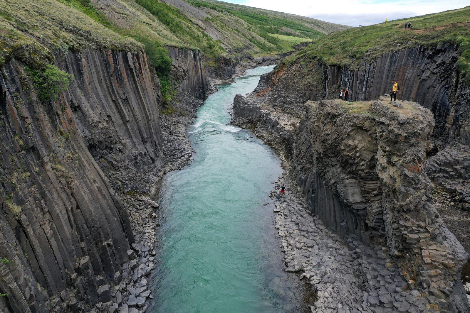
Stuðlagil is a canyon of tall basalt columns cut by the glacial river Jökla. Leave Route 1 in Jökuldalur for road 923, 112 km from Mývatn; the Grund parking is 131 km from Mývatn or, by the shortest route, 70 km from Egilsstaðir.
- Grund, for the viewing platforms: 19 km from Route 1, with toilets and several viewing platforms over the canyon. Vegagerðin is paving road 923 in stages; 4 km of gravel remain, and all our cars may drive it when it is open.
- Klaustursel, for the canyon floor: turn off at Hákonarstaðir, about 15 km up road 923, for the east side. The walk is about 5 km there and back from the parking by the waterfall Stuðlafoss, or 10 km from the bridge over the Jökla (Visit East Iceland).
- The color: blue-green, or grey-brown when the Hálslón reservoir overflows, most often from early August to October.
Stay on the trails
The rocks in the canyon can be wet and very slippery, and Jökla is a powerful glacial river: never enter it. Stay on marked trails, especially from 1 May to 10 June, when pink-footed geese nest.
Seyðisfjörður, Öxi and the passes in winter
Vegagerðin's winter service rules treat the roads of the East very differently:
- Seven days a week: Route 1 through the whole East, from Höfn to Mývatn, and road 93 over Fjarðarheiði to Seyðisfjörður.
- Six days a week: road 94 to Borgarfjörður eystri.
- Öxi and Breiðdalsheiði: two days a week in autumn (until 1 November) and spring (from 20 March) while snow is light; in between, once a week until 5 January, then only on request.
- Only on request, at most three times a week: roads 923 to Stuðlagil and 924. No winter service: road 901 by Möðrudalur and the access road to the Grund parking.
Seyðisfjörður: all traffic to the town crosses Fjarðarheiði at 620 m; a tunnel has been planned (in Icelandic), not built. The pass is cleared every day, but snow and wind can close it: check umferdin.is before you go, and cross in daylight.
Storms, wind and closures
Storms can close Fjarðarheiði and the highlands between Egilsstaðir and Mývatn for hours or days. Check the warnings on vedur.is: under an orange warning, drive only if you must; under a red one, don't travel. Never drive past a closure sign or onto a road marked Lokað, and in strong wind park facing into the wind and hold the doors firmly (rental terms 18; see Wind & car doors).
- Daylight: on 10 November the sun rose in Egilsstaðir at 09:19 and set at 16:04 (sunrise and sunset, in Icelandic); near the December solstice Reykjavík gets about four hours of daylight, and Egilsstaðir less.
- Tires and drive: winter tires on every car from 1 November to 14 April at no extra charge (rental terms 1); from November to March we strongly recommend AWD or a 4×4, which, as Safetravel notes, does not stop a skid on ice.
How many days for East Iceland
We suggest 6 to 11 days for Route 1, about 1,310 km around Iceland, and at least 10 in winter. Our day-by-day Ring Road itinerary gives the Eastfjords one day, with Djúpivogur and Seyðisfjörður as the standout stops. Add Stuðlagil (38 km there and back from Route 1), Hengifoss (68 km from Egilsstaðir) or Borgarfjörður eystri (142 km) and plan two or three days. For the drive to Höfn, see South Coast by car.
Which car, the ferry and returning the car
- Roughly May to September: Route 1 and the roads to Seyðisfjörður, Hengifoss and Borgarfjörður eystri are paved, so an Everyday car will do; choose a bigger one for more people or luggage.
- November to March: we strongly recommend AWD or a 4×4; Comfort is our default winter pick, and 4×4 Adventure and Highland 4×4 have more ground clearance.
The ferry from Seyðisfjörður
Our cars stay in Iceland: a car may not leave Iceland without our prior written consent (rental terms 25), and no cover option, at any tier, covers damage during ferry or sea transport, including sea spray (36(j)).
Ending your trip in Egilsstaðir? We rent from our office near Keflavík Airport, where the car goes back. A return in Egilsstaðir or another town is possible only on request, agreed in advance; we confirm the one-way fee in writing when we agree it (rental terms 11 and 40(o); see Locations).
Car trouble: call us day or night on +354 779 9499; in an emergency, call 112 (Accident & breakdown).
Questions about driving in East Iceland
How do I get to Stuðlagil canyon by car, and is the road paved?
Leave Route 1 in Jökuldalur for road 923. The Grund parking, with viewing platforms, is 19 km along it, the last 4 km gravel by Vegagerðin's calculator, and all our cars may drive it when it is open. For the walk to the canyon floor, turn off about 15 km up road 923 for Klaustursel, on the east side.
Should I take the Öxi shortcut (road 939) or Route 1 through the fjords?
Usually Route 1. Öxi is 67 km shorter between Djúpivogur and Egilsstaðir, but 25 km of that route is gravel, it is cleared only on some days in autumn and spring, and our rental terms allow it only in a four-wheel-drive car your booking confirms as F-road approved, when officially open.
Can I drive to Seyðisfjörður in winter?
Usually, yes: road 93 over the Fjarðarheiði pass (620 m) is cleared seven days a week. But it is the only road into town, and snow and wind can close it for hours or days: check umferdin.is and vedur.is before you set off.
How many days for East Iceland on a Ring Road trip?
Our day-by-day Ring Road itinerary gives the Eastfjords one day; we suggest two, three with Borgarfjörður eystri. For the whole loop we suggest 6 to 11 days, and at least 10 in winter.
Can I take my rental car on the ferry from Seyðisfjörður?
Our cars stay in Iceland: a car may not leave Iceland without our prior written consent (rental terms 25), and no cover option, at any tier, covers damage during ferry or sea transport, including sea spray (clause 36).
How far is Egilsstaðir from Reykjavík and Keflavík Airport?
By Vegagerðin's official distances, 634 km from Reykjavík and 677 km from Keflavík Airport via Akureyri and Mývatn, or 690 km and 730 km on Route 1 along the south coast. Visit Iceland puts the drive from Reykjavík at about 7.5 to 8.5 hours.
Can I return the car in Egilsstaðir?
Only on request, agreed in advance. We rent from our office near Keflavík Airport; for a return in Egilsstaðir or another town, we confirm the one-way fee in writing when we agree it (rental terms 11 and 40(o)).
Official sources
The facts on this page come from these sources (checked 10 November 2026):
- Distances between places (Vegalengdir) — Vegagerðin, in Icelandic
- Winter service: snow-clearing rules — umferdin.is (Icelandic Road and Coastal Administration)
- The East — Visit Iceland
- Stuðlagil canyon — Visit East Iceland
- Construction of Jökuldalsvegur to Stuðlagil — Vegagerðin
- Hengifoss — Visit East Iceland
- Fjarðarheiði tunnel: planning opinion (road 93 at 620 m) — Skipulagsstofnun, in Icelandic
- Weather warnings — Icelandic Met Office (vedur.is)
- Rental terms — Ring Road Cars